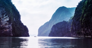


Asia Pacific Travel Team
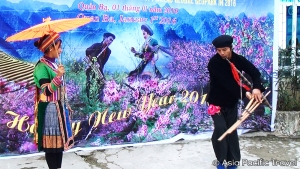
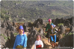
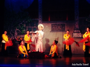
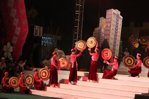
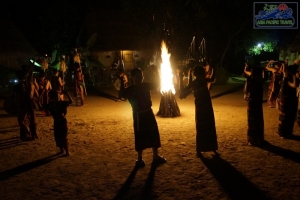
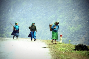
Khen Be - An unique musical instrument of Thai people
In his memory, his friends made copies of his Khen Be. Since that time, young Thai men have carried theses with them day and night.
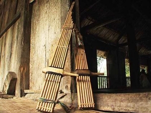
A Khen Be looks a little like a large scale mouth organ or pan pipe, but with a single cross pipe/ sound box, into which you blow to create the musical notes. The sound comes from tiny swinging reeds inside the bamboo tubes, with the notes changing by closing the holes on the tubes.
The Khen Be of the Thai people consists of fourteen small thin bamboo tubes, arranged together and decreasing in height with one end connected to a sound box. It is divided into two layers, each consisting of seven bamboo tubes. The sound box is made of wood, with the one end hollow for blowing into and the other sealed with max.
Whereas the Hmong Khen Be comprises only four hallow bamboo tubes attached to a sound box. The overall size of a khen be is determined by is maker, while the sound is dependent on the type of reeds used. These are usually made of bronze of silver, are as thin as paper, and are attached inside the bamboo tubes. Circular tones holes are made in the sound box.

Thus the tone, pitch and range of the instrument depend on its reeds and the distance between the holes. A Khen Be with a long loud low-pitch is commonly used by old people at home, while a shorter low and high-pitched one is used by young people.
Lo Van Nhoi, a famous khen be artisan says, “A good Khen Be while being played, should reveal its player’s and the maker’s innermost feelings.” Behind the severity and hardness of mountain living, the people are simple and quiet souls, and filled with the aspiration to be at one with nature.
The Khen Be is used in many difference aspects of daily life such as celebrations like the Lunar New Year festival, ceremonies to welcome guests and weddings. Its sound is seductive, whether it is played wild and fast or slow and gentle. The ethnic minorities use the Khen Be as an accompaniment to folk-songs and dances in their traditional festivals and when celebrating other significant events.
The music of the Khen Be has become an instrument of seduction used by young men to convey message and woo young women. When a young man knows how to hold and use a knife and hoe correctly to work in the field, it is also time for him to play the khen be well.
The people learn how to play the khen be not only to entertain, but also to show off their talents and help them to find their life partners. Young men of strong build who can play alluring khen be melodies easily win young women’s hearts.
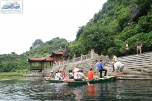
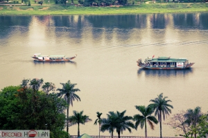
Peaceful in Con Vanh
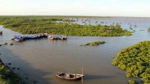
Con Vanh belongs to Nam Phu Commune, Tien Hai District, Thai Binh Province, 7km from the mainland. Due to being at the river mouth of Ba Lat, where the Red River flows into the sea, Con Vanh has a favourable position with beautiful and peaceful scenery. It is now a favourite destination for people who love to discover the diversified salt-marsh eco-system and the coastal fishing village with hospitable and humble people.
In the past, people had to row to Con Vanh but at the present time, there is a cement road connecting the island with the mainland. Lines of pine trees even make the way to Con Vanh more romantic. It was not hectic but so peaceful that surprised everyone a lot. At dawn, fishing boats come back after an overnight fishing trip. It’s time to come and buy fresh seafood such as crabs, prawns and stomatopods (mantis shrimps) at a much cheaper price than in the market. More interestingly, one can go into an inn to have the seafood boiled and served at once while enjoying the fresh air by the sea.
To the south of the long sandbar is Ba Lat lighthouse where visitors have a panoramic view of the whole Ba Lat river mouth – the joining point of the Red River and the seas of Nam Dinh and Thai Binh.
In the near future, Con Vanh will become a national tourism area with its striking features, including a primitive landscape, diversified eco-system and the simple life of fishing villagers. Con Vanh will also become one of the tourism routes in Thai Binh with Keo Pagoda, Tran Dynasty’s relics, Minh Lang Embroidery Village, Dong Xam Silver Village and Bach Thuan Garden.
Source: VNP
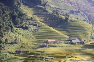
Phu Yen - An untapped tourism site
There are numerous nature-endowed scenic spots in the south-central province for visitors to explore, including unspoiled beaches.
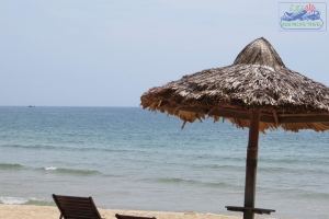
The provincial capital city of Tuy Hoa is adjacent to the sea. Beaches there are normally crowded with people going swimming when the sun begins to cast its first light or go down beyond the horizon. Watching the vast blue sea and white smooth sand can help people relieve themselves of the tiredness after working for long hours.

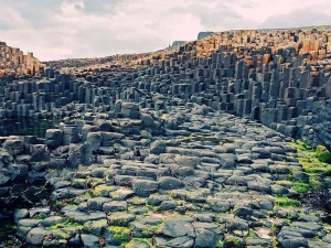
Phu Yen has some renowned tourism spots including Da Dia Reef and Dai Lanh
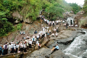
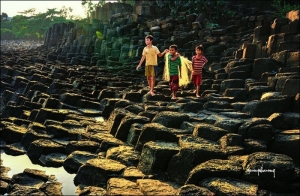
Cape as the country’s easternmost point. Da Dia Reef which was recognized as a National Heritage Site looks like an orderly beehive. For a long time, the reef has fascinated anyone paying a visit with a host of legends and stories about the site. Da Dia Reef is famous because the landscape is made of thousands of pentagonal rocks, causing passers-by to stop and contemplate the unusual and magnificent work of nature.
Meanwhile, Dai Lanh Cape where visitors catch the first rays of sunlight on the east coast of the country offers a special feeling. There, one side is the green mountains and forests while the other side is the deep ocean with its blue color combined with the light blue color of the sky as well as multi-shaped vertical cliffs. Under the cape is Mon Beach, a very clean and stunning beach where freshwater flowing from high mountains creates a lovely picture.

Dai Lanh Cape
The province has many large and small beaches that are described as primitive. Some beaches untouched by visitors are where local fishermen set sail to catch fish. Long Thuy Beach has swaying coconut trees while a fishing village is located in Vung Bau Beach. Bang Beach runs along the rock reef.
Phu Yen also possesses several attractive roads. One leading to Da Dia Reef undulating through mountains and forests overlooks hidden villages, busy markets and small houses scattered around. The road to Dai Lanh Cape is larger, running through Ca Pass to other famous heritage sites. Such winding roads along the mountainside and through the forest surely bring a sense of adventure to visitors.
It takes just a few minutes on foot to reach Nhan Mountain where there is a Champa-style temple. In daytime, tourists can gaze at the panoramic view of Tuy Hoa City, Binh Ngoc flower village, Da Bia Mountain, the East Sea and two bridges crossing the Da Rang River. During nighttime, they can admire the shimmering landscape as lights are turned on.

Nhan Mountain
Phu Yen is also attractive to people owing to its signature Ninh Hoa Nem (Ninh Hoa meat roll), girdle-cakes served with muong fish, O Loan cockles and Phu Yen steamed savory rice cakes. All these dishes have unique flavors of Phu Yen Province where human and nature are closely bonded.

Ninh Hoa Nem (Ninh Hoa meat roll)
It took more than 14 hours to reach Phu Yen from HCMC on a sleeper coach. I arrived at the coach station lying close to a local busy market bustling with trading activities taking place in the sun and sea breeze. Traders only have breakfast for relaxation following intense work starting early in the morning. Street food stalls selling steamed sticky rice, noodle soup and sandwiches are full of customers checking in and out while another stall nearby sells an assortment of sweetened soup.
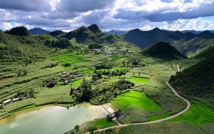
Flowers season in Ha Giang
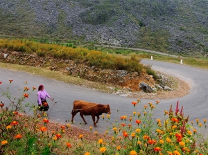
Ha Giang in early winter is not only dreariness pink of flowers triangular circuit but also bought the indescribable wistfully feeling and colorful flowers around many slopes. Therefore, travelers who first time come to here, will get lost in and dont't want to come back home.
Passing the flowers season in curve slopes, crooked of border area of China, the roadside flower colors make the journey becomes shorter. The brilliant colors of flowers around the spectacular mountains like the warm smile of people here.
Ha Giang in November bought to visitors the poetic beauty from the idyllic scenes and dearest.


A day in Binh Ba island
The venue, which used to be crowded with tourists on weekends only, is now turning a favorite destination as more and more people are visiting this place anytime, especially during summer.

Tourists can stop by Cam Ranh coach station, catch a taxi to Da Bac Port and then head for the island by boat. On average, there are four trips at three-hour intervals to Binh Ba every day, with each trip costing VND40,000 a person. Visitors can also choose to hire a private boat to reach the island.
The earliest trip at 7 a.m. in the morning is the most wonderful time when the sun begins to have its first light reflected on the ocean waves. Tourists will have a chance to gaze at a number of massive rocks in various shapes. Aside from ships taking visitors to Binh Ba and fishing boats, there are many smaller boats by islanders carrying necessities to and from the island.
Binh Ba is seen as a bustling island at the mere sight of its wharf area where visitors can find some small cafes to rest after a long journey on the sea. There are colorful electric vehicles available to take them to accommodation venues. The island does not actually have a lot of big hotels. However, most tourists prefer staying at locals’ homes for a new experience at an affordable price of VND50,000-100,000 a person for one night.

In the center of the island is a market where various fruit and vegetables as well as local specialties are sold while food stalls serving breakfast are always crowded. Besides, it is not easy to spot some restaurants offering an assortment of seafood dishes with fancy smell in the air. They are so irresistible that tourists have to stop by these places to try some local seafood dishes. On top of that, Binh Ba is dubbed the island of lobsters where tourists will have an opportunity to enjoy grilled lobsters caught fresh from the sea with appealing smell. Seafood on the island is fresh and cheap, attracting more and more travelers to Binh Ba.

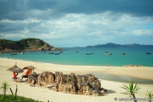
Nom beach
Nom Beach is one of the most beautiful beaches of the island with its incredibly white sand, crystal clear water and solid rocks standing tall nearby. Every evening, the beach becomes a busy place for local traders to do business. Meanwhile, tourists can admire beautiful coral reef and schools of fish swimming around on Chuong Beach, which is two kilometers far from the center of the island. They can also pay a visit to other great places such as Sa Huynh, Bo De and Nha Lau beaches.
Binh Ba Island has got livelier than before thanks to an increasing number of travelers going there. Local islanders can take advantage of their own homes as lodgings for visitors. A lot of local folks say they are very happy on seeing a lot of people visiting the island, thus making life there more dynamic. However, it is such a bustling and noisy part that has somehow taken the tranquility away from the island.
Discovering magnificent passes in South Central Coast
Discovering magnificent and risky passes of the South Central Coast will give us unforgettable experience with mixed emotions as well as strengthen our love for nature.
Following are a few prominent passes that are worth visits.
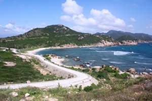
Vinh Hy-Binh Tien Pass

The 16-kilometer pass runs along the coast and Chua Mountain in Ninh Thuan Province, where there are unique dry forests in Vietnam.
Vinh Hy-Binh Tien Pass, starting from Vinh Hy Bay located 42 kilometers away from Phan Rang-Thap Cham City to the northeast, cuts through some canyons close to the shore. Travelers will be amazed by its wild beauty virtually untouched by human intervention as well as some overwhelmingly gorgeous beaches there such as Cha La, Rang, Nuoc Do, Kinh, Chuoi and Hoi, among others.
Along the pass are a number of spacious rest stops with protective railings and parking lots where travelers can freely admire spectacular views from a great height in a windy and cool atmosphere.
At the section from the peak of Chua Mountain to Binh Tien, travelers can view the southern part of Cam Ranh Bay as well as some islands and fishing villages that are described as a wonderful and poetic picture. The southern coast of Cam Ranh Bay linked with the foot of Chua Mountain is where there are a lot of fishing boats. Seafood there is extremely cheap at VND100,000 for a kilo of crabs compared to VND250,000 a kilo at some restaurants in the coastal city of Nha Trang.
Come to discover a number of scenic views along Vinh Hy-Binh Tien Pass, and you will see that landscapes in Vietnam are actually not inferior to any other places. That could be the reason why there are quite a lot of foreigners who prefer visiting such a spectacular pass.
Ngoan Muc Pass

Situated in the west of Ninh Thuan Province on National Highway 27, the 19-kilometer Ngoan Muc Pass, which connects Ninh Son Valley in the district of the same name and the eastern part of Don Duong District in Lam Dong Province, is one of the most beautiful passes in Vietnam. The pass called Belle Vue in French was opened in 1917 after French scientist Alexandre Yersin discovered Lang Biang Plateau in 1893.
On passing Ngoan Muc Pass, you will have a chance to see two giant hydraulic pipes bumping water from Don Duong Lake to Da Nhim hydropower plant that supplies power to the southern cities and provinces with the capacity of one billion kWh a year.
The winding road spiraling up the mountain looks like a lovely picture. Standing at a great height, you can gaze at a vast area of Phan Rang Plain and the Cai River while Phan Rang Valley is encased by mountain ranges at two sides stretching to the shore. You can also see the long coastline and white smooth sand that seems to spread endlessly. There are crystal clear streams flowing over the cliffs as well as massive areas of pine forests.
Ngoan Muc Pass is absolutely spectacular and well worth a visit for those who want to conquer such an amazing pass.
Bao Loc Pass

Bao Loc Pass is on National Highway 20 leading to Dalat City in Lam Dong Province. The 10-kilometer winding pass has many sharp bends. Two sides of the pass are high cliffs forming deep and foggy valleys. Primitive forests remain quite prevalent on certain rugged mountains above 1,000 meters.
The Central Highlands are home to marigold. The bright yellow flower begins to bloom on roads leading to plateaus from November, which makes Bao Loc Pass absolutely beautiful and appealing to any traveler.
Mimosa Pass

Opened several years ago, Mimosa Pass is Dalat’s backdoor with wide road and moderate slope. It stretches gracefully through immense pine forests, enormous farms and colorful flower fields. Along the pass, there are wild mimosa trees which bloom with glorious yellow during spring. On the way, you will be able to meet some skillful riders who are actually Dalat girls carrying vegetables on motorbikes at 50-60 kph, when people only dare to travel at 30 kph. The pass is 11 kilometers long and ends near Frenn Fall.
Visit Can Gio biosphere reserve
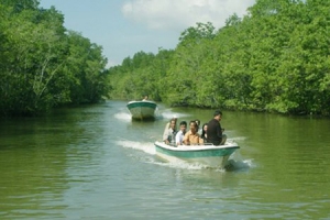
The special geographical position, along with the influence of the tide, has enabled Can Gio mangrove forest to receive a great deal of silt from the Dong Nai river and be endowed with rich and unique animals and plants, which has become the supply of food and sanctuary for both aquatic organisms and on-land vertebrates.
_jpg.jpg)
The forest is considered a “green lung” of the southwestern region, making the climate equable and preventing natural calamities.
The forest is populated by ‘Sac’, a type of mangrove tree, along with Aegiceras corniculatum (‘Su’), Bruguiera cylindrica (‘Vet’) and Rhizophora apiculata (‘Duoc’), which together form a large group of trees that are able to encroach on the sea.
In the 17th century, the forest counted 42,000 ha of primeval forest with hundreds of water birds and aquatic organisms such as shrimp, crab, fish and amphibians, as well as innumerable crocodiles.
However, from 1962 and 1971, this place became a “land of death” as a consequence of the US War and deforestation. Many species disappeared.
In 1985, local residents and soldiers strived to revitalise the forest. Their efforts were paid off with tens of hectares of the forest successfully revived and 60 flora species and dozens of water birds, such as pelicans, storks, and cranes, returning for sheltering.
After 30 years of restoration, about 30,500 ha of Can Gio mangrove forest has been recovered, creating a favourable habitat for many animals and plants.
The forest is now home to 157 flora, 70 invertebrate and aquatic species and 130 types of bird, along with 31 different reptiles, 11 of which are listed in Vietnam’s Red Book, such as geckos, pythons and cobras.
It has become an eco-tourism site and a place for domestic and foreign scientists to do more research about the botanical system there.
Vietnam is among the countries hardest hit by climate change, with its coastal region an extremely vulnerable area. Community-based management and development of mangrove forests has been underlined as effective way to strengthen coastal resilience against climate change.
The country has about 200,000 ha of mangrove forests.
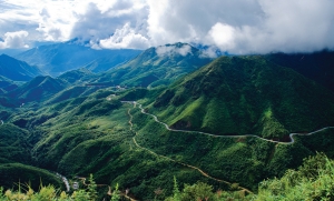
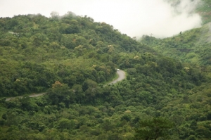
Stunning at Ma Pi Leng pass in Ha Giang

Passing through: Ma Pi Leng Pass is one of the highest passes in the country.
Ma Pi Leng Pass, also called the Great Wall of Viet Nam, is one of the four highest passes in the country, alongside Khau Pha in Yen Bai Province, O Quy Ho in Lao Cai Province and Pha Din in Lai Chau Province.
The pass is located in the globally recognised geological park Dong Van. It is not long, only 20km, but dangerously steep cliffs and deep mountainous slopes make the path difficult.
The pass's name literally means "nose of the horse". But figuratively, it means the mountain is difficult to access and riddled with obstacles – it's as vertical as a horse's nose.
On the way to Ma Pi Leng, we met children walking along the road. They liked watching visitors, and seemed glad when we gave them cakes, candies and scarves.
Sometimes on the side of the roads we saw small pubs that brought a wild beauty to the place. Some H'Mong men got tipsy and sat nodding by the roadside.
When we took in the view from the peak of Ma Pi Leng, mist covered the whole trail. We had never seen it look so mysterious before. It looked like paradise.
The pass's majestic and wild beauty makes it unique.
As we looked to the north and northeast, we saw thousands of grey mountains spreading up toward the horizon.

Ma Pi Leng pass and Nho Que river
Next to the path lied a chasm, and below us the Nho Que River ran like a colourful thread through the cliffs.
The H'Mong people's houses, surrounded by stone fences, perched on the edge of the chasm.
Some of the houses' walls were made of neohouzeaua, a kind of bamboo, which remained sturdy despite the region's wind and rain.
The Ma Pi Leng area was named a national sightseeing by the Ministry of Culture, Sports and Tourism on November 16, 2009.
According to the ministry's decision, Ma Pi Leng Pass is considered a special heritage area.
Ma Pi Leng's mountain top is one of the most beautiful observation points in Viet Nam, and Nho Que river's alley is one of the most unique tectonic valleys in Viet Nam.
Historical road
In addition to beauty, a history of volunteer youths building roads memorialises the Ma Pi Leng area.
The 185km road that goes to Ma Pi Leng Pass is called Hanh Phuc (happiness). It runs from Ha Giang City to Meo Vac District. It connects isolated mountainous districts and helps ethnic minorities access the plains.
Thousands of young people from 16 ethnic minority groups built the road between 1959 and 1965.
They had to string themselves up on the rock cliffs to make it through the dangerous 11-month building process.
At the beginning, the pass was only wide enough for pedestrians and horse-drawn carts. Later, it was widened so cars and vans could use it.
At the peak of Ma Pi Leng Pass and at the highest point of Hanh Phuc Road, we stopped to take photos of Nho Que river, enjoying a thrilling feeling. We also saw an old stone stele used for marking lengths during the pass's construction.

Hanh Phuc Road
It took the previous generation six years to make Hanh Phuc Road.
About 11 months of that time was spent making the 20km pass over Ma Pi Leng. But it took us only one day and one hour to trek across both. A feeling of admiration for the builders overwhelmed us.
The road instills happiness in ethnic minorities and visitors who have the chance to go and contemplate the country's boundless beauty.
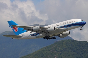
Jetstar Pacific opens Hanoi - Bangkok air route

This is the second direct flight route between Vietnam and Thailand operated by Jetstar Pacific. Earlier, the carrier opened ticket sales for the Ho Chi Minh city – Bangkok route, scheduled to depart from December 10th.
The Hanoi – Bangkok route is planned to be operated from March 29th, 2015 with a daily return flight. Flights from Hanoi numbered BL667 will depart at 12:25 pm while the return numbered BL668 will leave Bangkok at 15:35 pm. Every Tuesday, Wednesday and Saturday, the flights from Hanoi will depart at 12:00 pm and the return from Bangkok will take off at 14:40 pm.
Aiming to meet the demand for tickets soon and saving fees, tickets for the Hanoi – Bangkok route are being sold at www.jetstar.com and booking offices nationwide, or call 19001550.
Bay Nui (Seven Mountains) - The peaceful land and tranquil atmosphere
The region is endowed with many historical and cultural relics as well as stunning landscapes, so we have decided to make a journey to explore its cultural charm and natural beauty.
Before reaching Bay Nui, we have to conquer Ba The Mountain. The mountain, about 200 meters above sea level and by the poetic Thoai Ha River, is home to many species of monkeys, squirrels and herons as well as wild birds.
For pilgrims and architecture enthusiasts, Linh Son Co Tu Pagoda, Phan Thanh Gian Temple at the foot of the mount or Son Tien Tu Pagoda on its peak will offer elegantarchitecture as well as a peaceful and tranquil atmosphere. Some more things Ba The can feast tourists are Ong Ho and Ong Chot Ta caves where locals worship the goddess of mountain and tourists can find out masterpieces of nature.
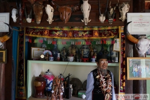
Thach Cha Ra, an elderly man who has been in Oc Eo Town, Thoai Son District for over 70 years, shares that he does not know when the name of Bay Nui was born but he has heard many folklores and enigmatic stories about the region that cannot be verified until now. He says the seven mountains namely Nuoc, Nam Gieng, Co To, Ket, Dai, Cam and Tuong are linked together into an arc.
Many ways to go to Bay Nui are surrounded by the ever green rice fields and water coconut farms with many pagodas and temples being scattered in between.
Co To Mountain appears dimply before our eye when we get closer to Tri Ton Town. The smell of fish starts reaching our nose as we can see tra fish being dried under the sun, which is a specialty of the region.

Co To Mountain
We continue the trip to Chau Doc Town where we find many fruit called ‘tram’ ripening in a vast color of purple and many water coconut trees as well as Khmer pagodas along the road. Even it is a bit late in the afternoon, many tourist groups gather at the foot of Cam Mountain to admire and say their prayers at Asia’s highest Maitreya Buddha statue measuring up to 38 meters.

The Maitreya Buddha on Cam Mountain in An Giang
Among seven mounts, Cam seems to be the most popular as it attracts a large number of tourists and pilgrims every day. Therefore, the fragrance of incense overwhelms the mountain and the trading ambiance is also busy along the way from the foot to the peak. The path is rather steep so we ask motorbike drivers to take us up to the top. Well, their riding can be likened to a very amazing performance of stuntmen.
When the sunset comes over the region, a giant rock in a shape of a parrot on Ket Mountain impresses us. That giant rock is a unique feature of An Giang. In the distance, Nha Ban Township is still kept busy with vehicles on streets even at dusk.

Ket Mountain
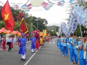
Touring to Bay Nui, no matter in the past or today, people often hear mysterious stories about fairies and goddesses. Bay Nui today is the home to ethnic groups of different religions from Buddhism, Caodaism, and Catholics, creating a mixture of cultures. Each year, the region witnesses many traditional festivals of Kinh and Khmer people, giving a chance for the community and other younger generations to practice and keep the tradition and old cultural values.
Along with thot not (water coconut), which is a local specialty to serve tourists and to help local residents earn more income, people in Bay Nui now develop other crafts like making thot not sugar and weaving brocade.
People to Bay Nui today have no chance to see horse carts but modern facilities and vehicles. More houses are built, more power poles go up, more pagodas are renovated and more roads are upgraded, promising a bright future for local living standards and tourism potential of the region.