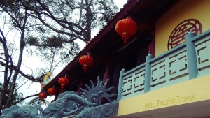


Asia Pacific Travel Team
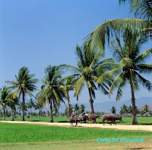
LONG AN PROVINCE
Square: 4,493.8 km2
Population: 1,446,200 people (2010)
City: Tan An City.
Districts: Ben Luc, Can Duoc, Can Giuoc, Chau Thanh, Duc Hoa, Duc Hue, Moc Hoa, Tan Thanh, Tan Tru, Thanh Hoa, Thu Thua, Vinh Hung, Tan Hung.
OVERVIEW
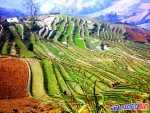
Located on the Mekong Delta, Long An is surrounded by Tay Ninh Province and Cambodia on the north, Ho Chi Minh City on east, Tien Giang Province on the south and Dong Thap Province on the west. Long An is divided into smaller areas by a complex network of rives and canals. Silt from Vam Co Dong and Vam Co Tay rives has raised the level of the field of Long An. This silt makes a good condition for agriculture. The terrain is quite flat except some hills and mounds on the north. The western area belongs to the Plain of Reeds.
GEOGRAPHY
Located on the Mekong Delta, Long An is surrounded by Tay Ninh Province and Cambodia on the north, Ho Chi Minh City on east, Tien Giang Province on the south and Dong Thap Province on the west.
Long An is divided into smaller areas by a complex network of rives and canals. Silt from Vam Co Dong and Vam Co Tay rives has raised the level of the field of Long An. This silt makes a good condition for agriculture. The terrain is quite flat except some hills and mounds on the north. The western area belongs to the Plain of Reeds.
CLIMATE
Long An is on tropical monsoon climate. The rain season lasts from May to October and the dry season lasts from November to April next year. Annual average temperature is 27.4ºC. Annual average rainfall is 1,620mm.
TOURISM
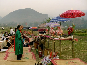
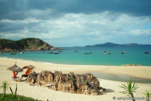
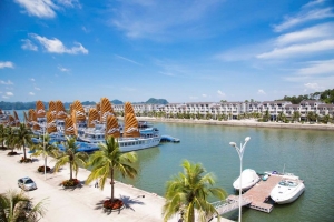
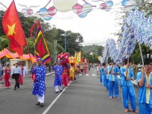
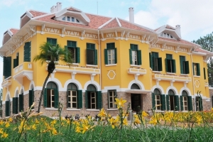
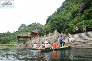
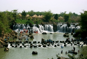
Visitors are attracted to Long An by value of Oc Eo culture that develops on the Mekong Delta from 1st BC to 6th century BC. 12,000 objects of 20 prehistoric monuments and 100 Oc Eo culture relics have been found. Beside these, Long An preserves valuable sites including House with Hundred Columns, Rach Coc Fort, Ton Thanh Pagoda. In Dong Thap Muoi Eco-tourist Site, tourists can discover many special flora and fauna and try typical dishes of the South.
TRANSPORT
Long An has National Highways No.1A crossing Tan An Town, National Highway No.62 linking to Binh Hiep Border Gate to Cambodia, National Highway No.50 from My Tho (Tien Giang) to Ho Chi Minh City via Can Duoc Townlet. Long An is 47km from Ho Chi Minh City.
CA MAU PROVINCE

Square: 5331,6 km2
Population: 1212,1 thousands people (2010)
City: Ca Mau City
Districts: Dam Doi, Ngoc Hien, Tran Van Thoi, Cai Nuoc, U Minh, Thoi Binh, Nam Can, Phu Tan.
OVERVIEW:
Ca Mau is a city located in southern youth of our country, formation and development from the town of Ca Mau in the early 20th century the town of Ca Mau and Ca Mau City today. Development process including the contribution of large communities of ethnic, makes mark on history emergency wild. The cultural value that is invaluable to potential tourists still leave unanswered.
GEOGRAPHY:
Ca Mau Province is situated in the southern tip of Vietnam with 307km coastal length. It is surrounded by East Sea on three faces and Kien Giang, Bac Lieu provinces on the north and north-east.
It's interlacing rivers and canals have generated tangled flows in the province. Seven large rivers are: Ong Doc, Bay Hap, Cai Lon, Ganh Hao, Dam Doi, Trem Trem, and Bach Nguu. Some offshore islands are: Hon Da Bac, Hon Khoai and Hon Chuoi.
There are two types of forest in Ca Mau province: salt marsh and cajuput. The cajuput forest has the highest biological value among other types of natural forest, with high economic value and environmental protection.
CLIMATE:
Ca Mau, with its sub-equatorial monsoon climate has two main seasons: the rainy season from May to October, and the dry season, extending from November to April of the next year. The province is average annual temperature is 26.5ºC. It is coolest in January with 25ºC. The annual rainfall averages 2,500mm, 90% of which is distributed over 6 months of the rainy season. Average humidity is about 80% in dry season and 85 % in rainy season. Ca Mau rarely suffers storms and floods.
TOURISM:
Ca Mau has great potentiality in ecological tourism thanking to salt-marsh ecological systems and diversified plants and animals. It has long seaside so there are many shrimp farms here. Then it is considered one of the key fishing grounds of the country, with great reserves of seafood of different types. Besides that, there are wild animals, such as deer, pig, and monkey.
Hon Khoai Island is a historical vestige that had related with the insurrection led by hero Phan Ngoc Hien. Ca Mau is famous for U Minh cajuput forest and Nam Can mangrove forest.
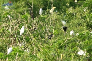
Rather than those, Ca Mau is also well known for its bird sanctuaries: Cai Nuoc, Dam Doi, Ngoc Hien... Most of all, Ngoc Hien bird sanctuary attracts more and more visitors.
TRANSPORTATION:
By Road: Ca Mau is 114km from Bac Lieu, 130km from Rach Gia, 180km from Can Tho, and 380km from Ho Chi Minh City. National Highways No. 1A, 63 connect Ca Mau to Bac Lieu and Kien Giang provinces.
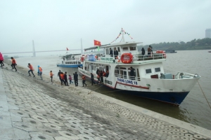
By Waterway: The boats run from Ca Mau to Ho Chi Minh City, Rach Gia. Tourist can visit U Minh and Ngoc Hien by ferry.
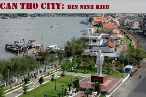
CAN THO CITY
Square: 1401,6 km2
Population: 1197,1 thousands people (2010)
Districts: Ninh Kieu, Binh Thuy, Cai Rang, O Mon, Phong Dien, Co Do, Thot Not, Vinh Thanh.
OVERVIEW:
“Can Tho with white rice and clear water
All who comes would never wish to leave”
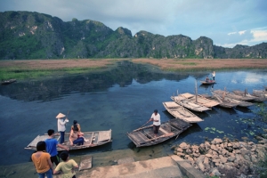
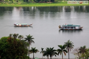
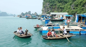
Can Tho has simple, poetic beauty with well-off villages under shade of coconut trees. It is wonderful to take a boat trip along the riverbanks on fine weather days.
GEOGRAPHY:
Can Tho City is located in the center of the Mekong Delta. It is contiguous to 5 provinces: An Giang on the north, Dong Thap on the north-east, Hau Giang on the south, Kien Giang on the west, and Vinh Long on the east. Can Tho has a complex of rivers and canals such as Hau, and Can Tho rivers, Thot Not, O Mon canals. Among them, the Hau River is considered a benefactor of this region, since yearly floods deposit large quantities of alluvia to the rice fields. Thank to that Can Tho becomes "the green lungs of the Mekong Delta"
CLIMATE:
The climate is harmonized with few of storms. It is hot, humid all year. Rainy season lasts from May to November, and dry season lasts from December to April. The annual average temperature is 27ºC.
TOURISM:
Can Tho is over its 200 years as the main town, once known as Tay Do and now one city of Vietnam. All of economic, culture activities closely relate to river and canals which like the 'street'. Can Tho has simple, poetic beauty with well-off villages under shade of coconut trees. It is wonderful to take a boat trip along the riverbanks on fine weather days. On the east bank of Hau River is Ninh Kieu Wharf, which is well known for its beautiful location. Other interesting places are Bang Lang Stock Sanctuary, Can Tho and My Khanh Tourist gardens and Can Tho Market.
TRANSPORTATION:
Can Tho is 34km from Vinh Long, 62km from Long Xuyen, 63km from Soc Trang, 104km from My Tho, 116km from Rach Gia, 117km from Chau Doc, 169km from Ho Chi Minh City and 179km from Ca Mau.
By Road: Can Tho has National Highway No.1A, 91, 80 linking to An Giang, Kien Giang provinces.
By Waterway: Can Tho has Cai Cui international seaport. The city is the centre of waterway network of Mekong Delta. There are daily hydrofoils between Ho Chi Minh City and Can Tho City.
By Airline: There is Tra Noc Airport.
CAO BANG PROVINCE
Square: 6724,6 km2
Population: 513,1 thousands people (2010)
Districts: Cao Bang Town, Bao Lac, Bao Lam, Ha Quang, Thong Nong, Tra Linh, Trung Khanh, Nguyen Binh, Hoa An, Phuc Hoa, Quang Uyen, Ha Lang, Thach An.
OVERVIEW:
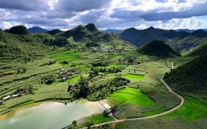
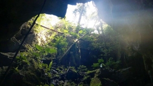
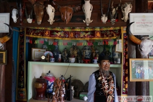
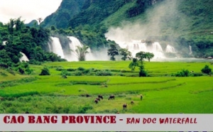
Cao Bang has great potentiality for developing tourism with both natural and cultural, historic tours such as tours to Pac Bo, Lam Son monuments, Tran Hung Dao forest, Dong Khe historical monument, the basement of the fort in Cao Bang town, Ban Doc waterfall, Nguom Ngao cavern, Thang Hen lake and border gates. Besides, in Cao Bang there are quite many ethnic groups with their own special traditions, customs and festivals, which is also good for developing tourism.
GEOGRAPHY:
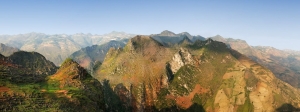
Cao Bang Province is located in the Far North - East, shares borders with China on the north and east, Bac Kan and Lang Son provinces on the south, and Ha Giang and Tuyen Quang provinces on the west. The topography is complicated so inter-transportation is limited.
CLIMATE:
Cao Bang has temperate climate. There are 4 seasons: spring, summer, autumn, winter. The average temperature is 25 - 28oC in summer and 16oC in winter. Snow sometimes falls in winter on high mountains such as Trung Khanh, Tra Linh.
TOURISM:
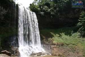
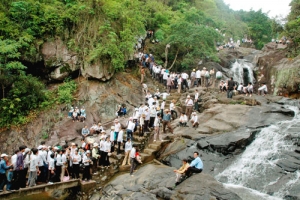
The cool weather combines with many high mountains, beautiful sightseeing to form the convenient for relaxing tour and discovery tour. Famous sites include Thang Hen Mountainous Lake in Tra Linh, Ban Gioc Fall and Nguom Ngao Cave in Trung Khanh. Among of them, Ban Gioc Fall probably is one of most beautiful waterfall in Vietnam. Several sites where Uncle Ho lived and worked before the August 1945 Revolution include Pac Bo, Coc Bo Cave, Lenin Stream, and Khuoi Nam Stream. In Cao Bang, the traditional festivals have specific characteristics of ethnic groups, for example, Long Tong Festival, Inviting the-Moon-Mother Festival (Moi Me Trang).
TRANSPORTATION:
Cao Bang is 272km north of Hanoi following National Highway No.3. Cao Bang has National Highway No.4B and 3 linking to Lang Son, Bac Can, Ha Giang provinces and to China. There are direct buses from Hanoi, Thai Nguyen and Lang Son.
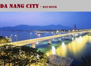
DA NANG CITY
Square: 1283,4 km2
Population: 926,0 thousands people (2010)
Districts: Hai Chau, Thanh Khe, Son Tra, Ngu Hanh Son, Lien Chieu, Cam Le, Hoa Vang, Hoang Sa
OVERVIEW:
The city is in the site of the East Sea and Han River with special different charms. Nature has offered the city a great position among three World heritages generously: ancient royal capital Hue, ancient city Hoi An and Holy land My Son. Thanks to this, Da Nang plays an important role in hosting, serving and transferring visitors. Not only being in the middle point of three world heritages, but also does it have numerous unforgettable beautiful scenes.
GEOGRAPHY:
Da Nang City is located in middle of Central Vietnam, between Hanoi and Ho Chi Minh City, separated from Laos by the western Truong Son Mountains. It is surrounded by Thua Thien-Hue along the northern border and Quang Nam on the southern border. It is embraced by the East Sea with 150km of seacoast.
Topography is rather complex. The south is impressive Hai Van Pass with Mang Mountain 1,708m, Ba Na Mountain 1,487m. The east is Son Tra Peninsula, an ideal site of yellow sand beaches, historical remains, and rare bird and animal species. The south is Ngu Hanh Son (Marble Mountains). The seashore is Hoang Sa archipelago with a large fishery.
CLIMATE:
Da Nang is located in the zone of typical tropical monsoon, temperate and equable climate. The city's weather bears the combination of the north and the south climate characters with the inclination to the former. There are two seasons: the wet from August to December and the dry season from January to July, cold waves are occasional but they are of average and short lasting. Average humidity is 83.4%.
Average temperature is about 26ºC, the highest is 28-30ºC in June, July, August, the lowest is 18-23ºC in December, January, February. In Ba Na Mountain, the temperature is 20ºC. Average rainfall is 2,505mm per year that concentrates during October and November.
TOURISM:
Da Nang is an ancient land, closely related with the Sa Huynh cultural traditions. Many imposing, palaces, towers, temples, citadels and ramparts, the vestiges from 1st to 13th are still to be seen in Cham Museum.
Da Nang has other various interesting attractions as Ba Na Tourist Resort, Ngu Hanh Son (Marble Mountains) as well as the Linh Ung Pagoda, Han River, and My An, Non Nuoc beaches, stretching on dozens of kilometers...
TRANSPORTATION:
By Road: Da Nang is 108km from Hue, 130km from Quang Ngai, 763km from Hanoi, and 947km from Ho Chi Minh City.
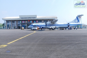
By Air: The Da Nang International Airport is 2.5km south-west of the city center. There are domestic flights to some cities. There are direct flight from Bangkok, Hong Kong, Siem Riep, Taipei and Singapore to Da Nang City by Vietnam Airlines, PB Air, Siem Riep Air way, Far Transportation and Sil Airway.
By Train: Thong Nhat Express train, which connects Hanoi and Ho Chi Minh City, stop in Da Nang.
By Waterway: There are marine routes to international and domestic ports. Tien Sa and Han River ports are located in a very wonderful position.
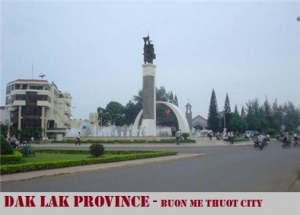
DAK LAK PROVINCE
Square: 13125,4 km2
Population: 1754,4 thousands people (2010)
City: Buon Me Thuot City
Districts: 18 districts
OVERVIEW:
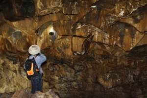
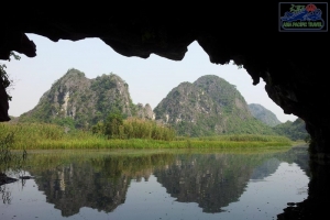
There are beautiful and famous waterfalls such as: Thuy Tien, Trinh Nu, Krong Kmar, Bay Nhanh, among many big lakes such as Lak, Dak Mil. Coming to there, tourists are able to get in the primitive forests of the Chu Yang Sin, Yok Don National parks, visit Buon Don that is a well-known local of hunting and taming wild elephants, or make tour to Dak Lak's historical vestiges like Bao Dai Palace, Yang Prong Tower, Buon Ma Thuot Prison, Dak Tua Cave.
GEOGRAPHY:
Dak Lak is located in southwest of Truong Son mountains with 11030’–13025’ North latitude and 107030’–109030 East longitude.
The province borders to Gia Lai Province to the North, Lam Dong and Binh Phuoc Provinces to the South, Khanh Hoa and Phu Yen Provinces to the East and Cambodia to the West with 240km of common frontier.
CLIMATE:
Tropical monsoon climate with two distinct seasons. Rainy season lasts from May to October, and dry season lasts from November to April. Average annual temperature is 24C/75F.
TOURISM:
One of strong forces of Dak Lak Province is tourism. There are more and more investments in this field of activities for more efficient deployment. Average growth rate for period 1990-2000 was 30% per annum. In 1995, the province met only 70,100 participations, (4,250 participations of foreign travelers). In 2000, this number increased to 132,550, among which 7,790 man-times of foreign tourists. For the next period, Dak Lak Province has decided that the tourism is a breakthrough industry for the economic structural movement.
Dak Lak is a mountain province that is rich of big tourist potentiality. There are little places in the world that have so many beauty-spot as in Dak Lak province. The most famous sceneries are world-famous waterfalls such as Dray Sap, Gia Long, Trinh Nu, Krong Kmar, Bay Nhanh, Thuy Tien, Ba Tang..., large lagoons of 200-600ha area such as Lak, Ea Kao, Ea Don, Tay Lakes … suitable for sailing, surfing, fishing, entertainment activities. Coming to Dak Lak, travelers could visit primeval forests with diversified ecological systems and species in Yok Don National Park, Nam Ka Special Forest, Nam Nung, Ta Dung Conservation Zones. Constant development of hunting elephants and other big forest animals from time immemorial has made Buon Don regionally reputed as the brisk trading centre on the Central Highlands. Lac Giao Communal House is the place with stamps of Viet’s people on the highland. There are private palace of ex-imperator Bao Dai, Yang Prong Town – the Cham’s construction built in XIV century, Buon Ma Thuot Prison, Dak Tuor Cave, provincial museum in the center of Buon Ma Thuot City with small rough model of Buon Ma Thuot Victory in the all-out attack in the historical spring of 1975… Particularly, if Buon Ma Thuot City is taken as center, then almost all beautiful spots and relics of Dak Lak Province are within a circle of radius less than 50km that is very suitable for tourism.
On the other hand, Dak Lak is famous by its rich and multiform culture of customs and habits. There are not only imposing cultural heritage of native ethnic groups such as Ê dê, M’nông with remarkable epics such as Dam San, Dam Bri, Xinh Nha, genie lunar New Year pole, but also valuable tangible cultural heritages dan da (stone musical instrument), gongs.
TRANSPORTATION:
Dak Lak has important national roads such as National Highway 14 from Da Nang via Buon Ma Thuot City to Ho Chi Minh City, National Highway 26 to Nha Trang, National Highway 27 to Da Lat, National Highway 28 to Phan Thiet. Dak Lak also has airport connecting Ho Chi Minh City, Da Nang, Hanoi and quite large internal inland roads.
Buon Ma Thuot Airport at the present performs two main routes: Buon Ma Thuot - Da Nang - Hanoi, Buon Ma Thuot - Ho Chi Minh City
Current inland roads system consists of:
+ National Highways: There are 5 lines with total length of 700.2km, in there:
- National Highway 14 of 272km long and national Highway 26 of 119km. Roads of mountain III level with asphalted surface and permanent drainage.
- National Highway 27 of 83.2km long. Roads of mountain IV level with asphalted surface and 28.2km of permanent drainage
- National Highway 28 of 58km long and National Highway 14C of 168km. Roads of mountain IV level. At present roads are with soil surface and temporal bridges and sewers with asphalted surface and permanent drainage sewers.
+ Provincial roads comprise 16 lines with total length of 610km of IV level mountain roads, in there 151km are asphalted, 30km are covered by asphalted concrete and 117km are covered by gravels. 44 bridges with 716m length are permanent and 44 temporary bridges of 560m long.
+ District roads consist of 77 lines of 806km long mainly of IV and V mountain level. Among them 61km have been asphalted, 178km covered by gravels, the remaining are soil covered. Eleven bridges of 108m long are permanent.
+ Urban roads have 109.5km length, in which 54km asphalted.
+ Roads in rural areas have length of more than 4400km. They mainly are covered by soil with about 200 bridges of 1200m long.
Average density of automobile roads on natural area is 0.435km/km2, in average, ration of automobile roads to 1000 people is 0.506km/1000 persons.
DAK NONG PROVINCE
Square: 6515,6 km2.
Population: 510,6 thousands people (2010).
Town: Gia Nghia Town.
Districts: Dak Nong, Dak R'Lap, Dak Mil, Dak Song, Cu Jut, Krong No, Tuy Duc.
OVERVIEW
Dak Nong Province is surrounded by Dak Lak Province, Lam Dong Province, BinhPhuoc Province and Cambodia. Gia Nghia Town is 245km from Ho Chi Minh City, 179km from Phan Thiet (Binh Thuan) and 125km from Buon Ma Thuot (Dak Lak). The average temperature is 24ºC. Dak Nong is suitable for tourists who like discovering superb natural fall scenery.
HISTORY
Until recently, Đắk Nông was part of the larger Đắk Lắk Province, but is now fully independent. Before 1975, Đắk Nông was part of South Vietnam (Republic of Vietnam), and Đắk Nông Province was formerly named Quang Duc Province, but after the 1975 Viet Cong conquest over the South in the Vietnam War, Quang Duc was conjoined with Đắk Lắk Province. For Đắk Nông's history, please see Đắk Lắk Province.
GEOGRAPHY
Dak Nong Province is located on Central Highlands. It is surrounded by Dak Lak Province on the north, Lam Dong Province on the east and south-east, Binh Phuoc Province and Cambodia on the west.
Dak Nong has even and flat terrain with vast plain and plenty of grasslands on the east. The south is flood plain with many lakes and lagoons. There are main rivers such as Ba, Serepok, other small rivers, and high waterfalls.
CLIMATE
The weather is quite temperate. The average temperature is 24ºC. The dry season extends from November to April following year. It is windy, cold and dry. The rainy season lasts from May to October with high amount of rainfall.
TOURISM
Dak Nong has flat cultivated surface, mainly bazan. So the province has the advantage for industrial tree especially coffee tree. By there, the traditional culture of ethnic groups is diversified and distinct.
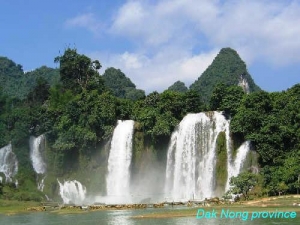
Dak Nong is suitable for tourists who like discovering superb natural fall scenery. Coming to Dray Nur Waterfall, one can hear the murmur sound of its flow from afar, and coming nearer, the sound becomes roaring. In Gia Long Waterfall, the flow is much smoother. Its stream does not flock into one side but gently passes through stones, tree roots and then runs to rivers. Apart of that, let save your time to visit Dray Sap Waterfall (Misty Waterfall), Ba Tang, and Dieu Thanh waterfalls.
TRANSPORT
Dak Nong has transportation mainly by road. Gia Nghia Town is 245km from Ho Chi Minh City by National Highway No. 14 then No.13, 84km from Di Linh (Lam Dong) by National Highway No. 28, 179km from Phan Thiet (Binh Thuan) by National Highway No. 28, and 125km from Buon Ma Thuot (Dak Lak) by National Highway No. 14.
DIEN BIEN PROVINCE
Square: 9562,9 km2
Population: 504,5 thousands people (2010)
City: Dien Bien Phu City
Districts: Muong Lay town, Tua Chua, Tuan Giao, Dien Bien Dong, Muong Tra, Muong Nhe, Dien Bien.
OVERVIEW:
Dien Bien is a new province which was created by a split of the former Lai Chau Province in the early 2004. Điện Biên Province includes all the land in the south of Da River (Black River), and New Lai Châu Province includes all the land in the north of Đà River.
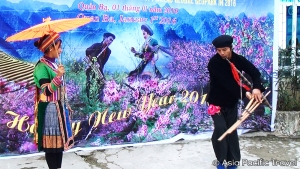
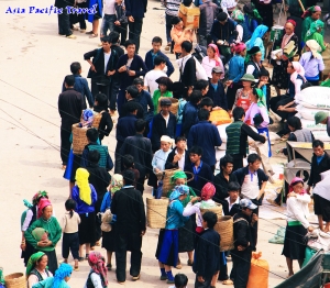
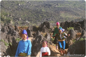
Travel in this region offers the best opportunity to meet and greet people of ethnic-minority hilltribe groups, from the timid White Thai to the gregarious Hmong. But remember that responsible tourism is crucial; our collective interaction with isolated ethnic minorities lays the groundwork for their future survival (or demise). Hire guides if you are going off into the boonies or out among ethnic groups. Your impact, especially if your travels take you to real rural parts, is important.
GEOGRAPHY:
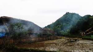
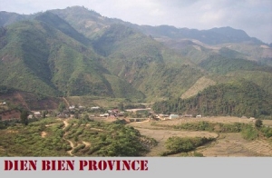
Dien Bien Province is on the North - West Vietnam. It is next to Lai Chau, Son La provinces, Laos and China. The province has many mountains stretching along north-west and south-east direction. Muong Thanh Valley is largest one of this region. The topography includes forests, high mountains, narrow valleys, small plains, and springs.
CLIMATE:
Dien Bien is mountainous tropical area. There are the dry and the rainy seasons. The average temperature is about 21ºC - 23ºC.
TOURISM:
Dien Bien possesses charming natural scenery such as Pa Khoang Reservoir, Tham Bang Cave, Ban Phu Citadel, Museum of Dien Bien Phu Victory. Dien Bien are also proud of many historic sites: Noong Nhai Vestige, Muong Phang Forest, especially, Dien Bien Phu Vestige with a global well-known victory in 1954.
Traveling from Hanoi to Dien Bien Phu, it takes 1 hour by plane. But by road, travelers go over kilometers of mountainous road and cross Pha Din Pass. The stretch of road goes uphill and downhill alternately with many sharp bends. It is a memorable event for everybody in this superb mountain.
TRANSPORTATION:
The network of road is convenient include:
- It takes 478km from Hanoi following National Highway No. 6 to Tuan Giao and then the 279 to Dien Bien Phu.
- It is 195km from Dien Bien Phu to Ma Lu Thang border gate (Lai Chau) following National Highway No. 12.
- The National Highway No. 279 links Tuan Giao to Tay Trang border gate vise Dien Bien Phu.
Beside that, there is Muong Thanh Airport in Dien Bien Phu, connecting Hanoi - Dien Bien Phu.
DONG NAI PROVINCE
Square: 5903,4 km2
Population: 2569,4 thousands people (2010)
Districts: Long Khanh town, Tan Phu, Dinh Quan, Vinh Cuu, Thong Nhat, Xuan Loc, Long Thanh, Nhon Trach, Cam My, Trang Bom.
OVERVIEW:
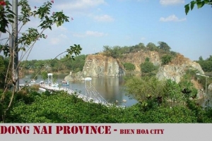
Dong Nai has a developing industry. There are many big industrial zones, factories, handicraft village (Tan Van pottery village, skilful stone carving of Hoa group). Dong Nai's pottery has well-known beauty. The province own immense coffee, rubber farms and Nam Cat Tien National Park. Coming here, tourists have ecological tours in forests and orchards in My Quoi, Thanh Hoi, Tan Trieu, Pho, Ong islets. The province is proud of many interesting sites such as Dong Nai River, Long An Lake, Suoi Tre Culture Site, Tri An Waterfall, Ma Da and Sac forests.
GEOGRAPHY:
Dong Nai is located on the south of Vietnam. It is surrounded by Lam Dong in the north, Binh Thuan in the east, Ba Ria - Vung Tau in the south, Binh Duong, Binh Phuoc and Ho Chi Minh City in the west.
The topography includes some valleys, lowland, hill. The main kinds of land are bazan, alluvial soil. Therefore, it is good condition for industrial plants (rubber, coffee), and orchard.
CLIMATE:
There are two seasons: the rainy season lasts from May to October and the dry season lasts from November to April next year. The annual average temperature varies between 25.4 and 27.2ºC.
TOURISM:
Dong Nai has a developing industry. There are many big industrial zones, factories, handicraft village (Tan Van pottery village, skilful stone carving of Hoa group). Dong Nai's pottery has well-known beauty. The province own immense coffee, rubber farms and Nam Cat Tien National Park.
Coming here, tourists have ecological tours in forests and orchards in My Quoi, Thanh Hoi, Tan Trieu, Pho, Ong islets. The province is proud of many interesting sites such as Dong Nai River, Long An Lake, Suoi Tre Culture Site, Tri An Waterfall, Ma Da and Sac forests.
TRANSPORTATION:
Bien Hoa City is 30km from Ho Chi Minh City, 1,684km from Hanoi following National Highway No.1A. It also is 278km from Da Lat, 95km from Vung Tau, 198km from Can Tho. The Thong Nhat Express Train connecting Hanoi to Ho Chi Minh City, stops at Bien Hoa.
DONG THAP PROVINCE
Square: 3375,4 km2
Population: 1670,5 thousands people (2010)
City: Cao Lanh City
Districts: Sa Dec Town, Tan Hong, Hong Ngu, Tam Nong, Thanh Binh, Thap Muoi, Cao Lanh, Lap Vo, Chau Thanh, Lai Vung.
OVERVIEW:
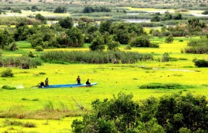
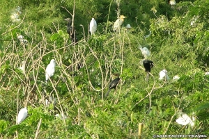
Dong Thap is particularly famous for its natural scenery, with several bird grounds. The most noteworthy is the breeding ground of red-headed cranes, which are very rare in the world. Some places of revolutionary interest are open to tourists.
GEOGRAPHY:
Dong Thap is on the Mekong Delta, one of three Dong Thap Muoi's provinces. It shares its border with Cambodia on the north, Vinh Long Province and Can Tho City on the south, An Giang Province on the west and Long An, Tien Giang provinces on the east.
Dong Thap has quite developed system of canals for watery transportation and irrigation. The province has about 10,000 hectares of forestland. Cajuput is specific tree of Dong Thap Muoi region. There, the system of fauna and flora are multiform with many valuable kinds: tortoise, turtle, snakes, fishes, shrimps, pythons, storks, birds, rice, lotus, water lily, grass, and alga especially red headed cranes.
CLIMATE:
The province has tropical climate, plentiful fresh water in the whole year-round, rich and populous land with verdant fruits trees in all four seasons. There are two obvious seasons: rainy season from May to November; dry season from December to April. Average annual temperature is about 27ºC. The average annual rainfall is 1,174 -1,518mm.
TOURISM:
Every year, Tien and Hau rivers provide alluvial soil for Dong Thap that is convenient to growing food and fruit plant. So this area is the granary of Vietnam. The province has potentiality of short day crops (sugar cane, cotton, tobacco, soil bean, and other fruit plants with the popular names of Cao Lanh mango, Chau Thanh longan, Lai Vung mandarin, Phong Hoa grape fruit.
From January to May every year, when sky is clear, tourist would visit Tram Chim National Park to observe many cranes. It is crane flock returning after months of emigrating to evade flood. This is also the season for tourists to see, photograph cranes in the dawn and sunset.
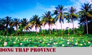
Tourists can admire the vast lotus and bonsai in Sa Dec Flower Garden. A forest of flowers of all colors and aroma are always available here.
Dong Thap has relic of Oc Eo Culture in Go Thap, numerous historic remains and valuable places of scenic beauty like the Tomb of Junior Doctor Nguyen Sinh Sac, Go Thap Site, Xeo Quit Relic, that are being protected, preserved and step by step put on operation for economical and social development of the province.
TRANSPORTATION:
Cao Lanh City is 162km from Ho Chi Minh City. There are direct buses from Ho Chi Minh City, My Tho, Can Tho, Vinh Long, and Long Xuyen. Sa Dec Town is 143km from Ho Chi Minh City, midway between Vinh Long and Long Xuyen.